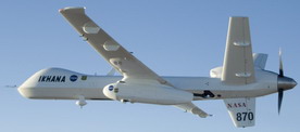
In addition to the DC-10 air tanker that’s been getting a lot of press, we also have a new NASA drone aircraft called Ikhana helping out with California wildfires by using advanced thermal-infrared imagery to give firefighters a more accurate picture of fire activity on the ground.
Today’s Mercury News reports:
Ikhana, NASA’s pilotless aircraft, flew over the 47,000-acre Lick fire for the first time, transmitting images and information to firefighters below as they battled the blaze into Saturday evening.
“They used that to facilitate their planning for the day’s firefighting,” said Vince Ambrosio, NASA Ames’s principal investigator on the Ikhana project.
Ambrosio monitored the drone’s flight from a base in Boise, Idaho, while other NASA technicians on the ground interpreted the images for fire commanders. Altogether, Ambrosio said, Ikhana flew 20 hours, starting Friday night from NASA’s facility at Edwards Air Force Base to 11 fires in California, Oregon and Washington before returning to Edwards on Saturday afternoon.
You can read more details on the wildfire imaging mission in the NASA Dryden press release. Also check out NASA’s photo and video collections for Ikhana.
Other coverage includes Aviation Week, Firefighter Blog, and Skycontrol.